Home
Have your say! Oct 22' survey results
Have your say!
Let us hear your views on the early-stage design options for improving Down Lane Park!
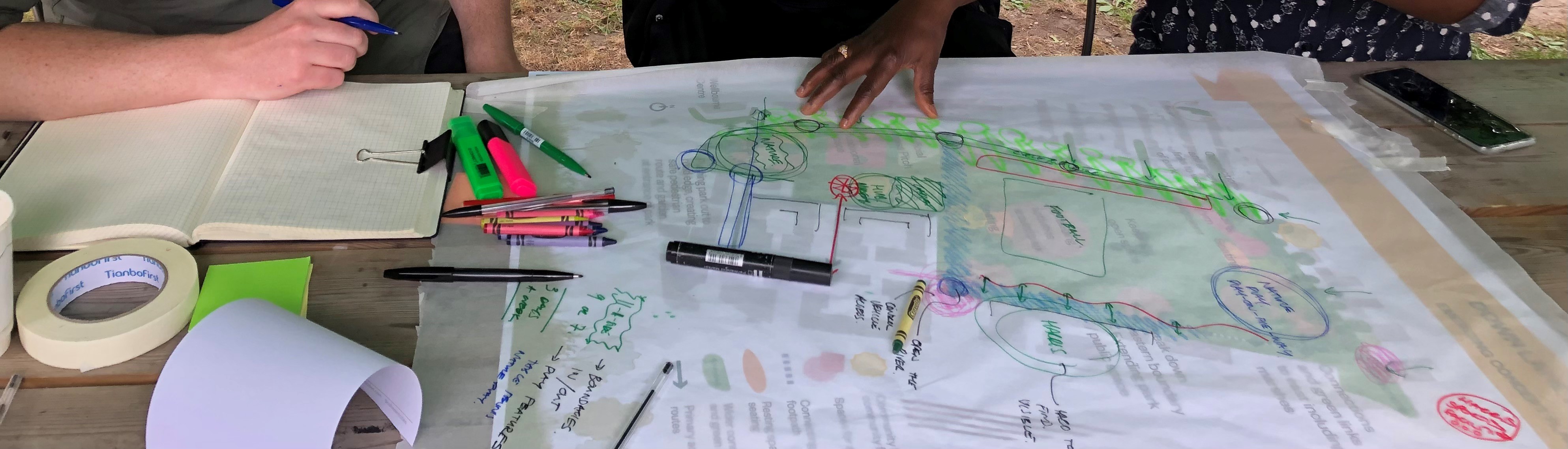
Haringey Council has been working with the Community Design Group and Levitt Bernstein Landscape Architects to develop two early-stage design options to improve Down Lane Park.
The two design options (Options 1 & 2) show how the different elements of the park like pathways, entrances, sports facilities and play spaces could be redesigned to better meet the needs and aspirations of local residents, park users, and the wider community. Some design elements are common to both options, others are interchangeable.
We invite you to view the early-stage engagement boards by selecting the link below. These boards provide greater detail on the proposals in each of the two early stage design options.
Check out the early-stage engagement boards here.
Take the Survey. Have your say!
Your feedback is really important to us and will be used to inform the next stage of co-design through the winter and into the spring. There are 20 questions in the survey and it should take you roughly 10 minutes to complete. Once you've completed the survey you'll have the opportunity to opt into a prize draw and win one of five £50 shopping vouchers for ASDA..
Select next in the bottom right of the screen to start the survey.
 These are the priorities developed with the Community Design Group that we’ll deliver on:
Ecology
- Increase the amount and useability of green space
- Improve drainage, ecology and biodiversity, and climate change resilience
Safety
- Make sure the park is welcoming and safe and discourages anti-social behaviour
- Improve use of the park by all residents and improve equality of access for groups which are often under-represented in parks including women, young people, ethnic minorities and people with disabilities
- Offer safe, attractive walking and cycling routes in the park and wider area
Facilities
- Enhance sports and recreation facilities
- Provide a permanent community hub and garden within the park
Function
- Respond positively to the changes happening around the park
- Improve green connections between Tottenham High Road and the Lee Valley
Entrances & Boundaries
2. New entrances
Both options propose new entrances and improvements to existing entrances into the park.

Four new park entrances are proposed, marked 5, 6, 7 and 8 in the design options above.
These provide more options for people to access and move through the park and connect to wider green routes in the area.
These new connections would create new public access routes across previously private land and that have been secured through the planning process.
Entrances & Boundaries
3. Routes
One of the priorities for Tottenham Hale is to protect and enhance its existing green spaces and improve links between them, creating a joined-up network of landscaped walking and cycling routes from Tottenham High Road to the Lee Valley.
Green & Open Spaces Strategy, 2016

Down Lane Park sits at the heart of this, with both early-stage design options introducing new entrances and pathways which help connect the park to the wider local and strategic movement network.
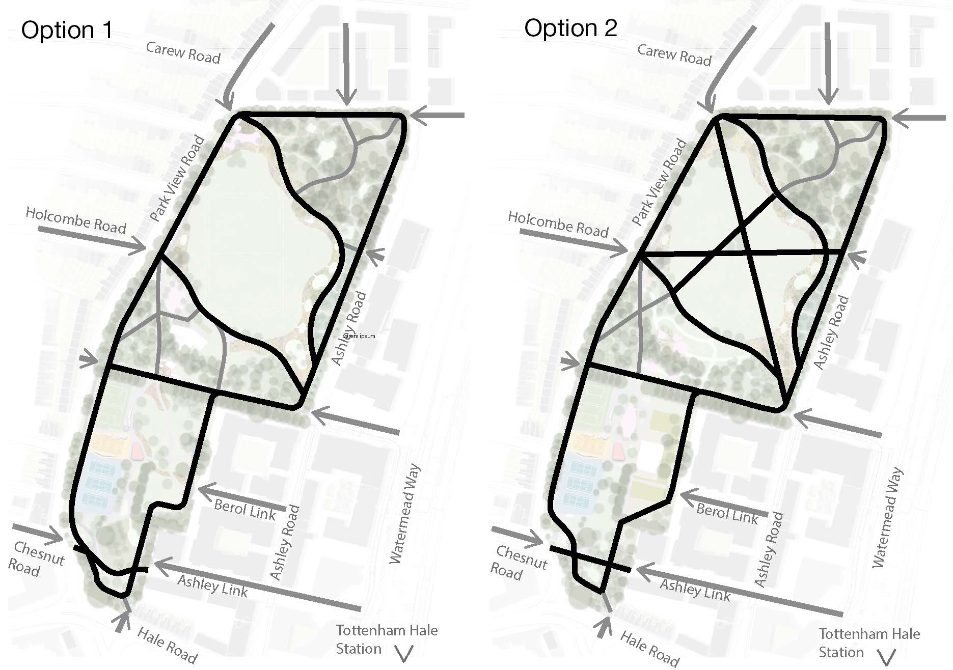
Option 1
Option 1 proposes sweeping pathways that go around the northern part of the park, connecting facilities within the park and leaving a large, flexible central grass area that allows for 11-a-side football and events in the park, which help to meet park maintenance costs. It includes a perimeter 'activity route' with distance markers for walking, jogging, cycling.
This option introduces wild planting and different ground heights to encourage people to take these sweeping paths, rather than walk directly over the grass. Overall, this option provides a greater amount of green space and less hard surfaced pathways but offers less direct routes.
Option 2
Option 2 proposes straighter, more direct pathways that cut across the northern part of the park and enable people to move from one entrance to the other quickly, responding to regularly used cut-throughs. It includes a perimeter 'activity route' with distance markers for walking, jogging, cycling.
This option creates smaller pockets of green space in the northern part of the park, which can be used for kickabout ball games and smaller gatherings, but not 11-a-side football which may limit events in the park that help to meet park maintenance costs.
Overall, this option provides a greater amount of hard surfaced pathways and less green space.
Entrances & Boundaries
4. Pathways
Previously we’ve been told that pathways in the park are too narrow and asked if cycle lanes can be introduced alongside pathways. Pathways are currently used by both pedestrians and cyclists, which can lead to conflict over who has right of way and has been raised as a concern by some residents and park users.
At present the council is consulting on a plan to reduce traffic around the park and make roads safer for pedestrians and cyclists, by introducing a Streets for People scheme between Hale Road and Northumberland Park. If introduced this would create better conditions for cycling in and around the park.

View of existing pathways in the park
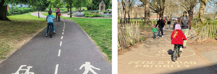
Example image of shared pathways
Entrances & Boundaries
5. Park boundary and railings
At present only the sports facilities and buildings within the park are locked at night and the park gates are left open. The design option proposals include the removal of railings around the edge of the park, replacing them in most areas with low-maintenance planting (similar to the 'natural boundaries' exemplar images shown below).
This allows for additional informal entrances into the park, helps to support biodiversity, and encourage additional planting to spill out, which would help to green the adjacent streets, also making the park feel bigger and more accessible. They would, however, require more maintenance than fixed railing boundaries. Proposals would focus on keeping children and vulnerable people safe from the road edge, whilst also preventing unauthorised vehicles accessing the park.
 Existing boundary railing

Example image of natural boundaries.
Community Space
6-10. Community Hub Building

View of the existing nursery and community hub in the former park pavilion building in the park.
Existing Pavilion Building
At Down Lane Park the former park Pavilion building is an important destination providing a privately run children’s nursery and a community hub, run by Living Under One Sun and supported by the council, offering community development and support services, an enclosed outdoor space for community growing and activities, and delivering programmes of free activities and events inside the hub and within the wider park.
New Community Hub
Through this project we will co-design proposals to create a refurbished or new purpose-built community hub within the park, providing an improved resource for Tottenham Hale’s communities.
While we have yet to develop design proposals for the building itself, which will involve further discussions with the Planning department, existing tenants and others, we have developed two options for the Hub’s location within the park.
Option 1: Centralised Community Hub Building
This option raises the prominence and visibility of the community hub, enabling views over the park, and enhancing activity and natural surveillance. It is more-or-less equally accessible from all directions. Relocating the hub would involve a complete redesign, providing greater flexibility in how it is orientated and laid out internally and externally. Not being located along the park edge may create some design issues.
Option 2: Southern Community Hub Building
This option maintains the community hub in the same area of the park as presently, which people are familiar with, close to the sports pitches. It is more immediately accessible from the southern end of the park. Maintaining the hub in this location would need to consider refurbishment and extension, which may limit orientation and internal and external layout. Refurbishment and extension or new build in this location would need to work with the existing surrounding context
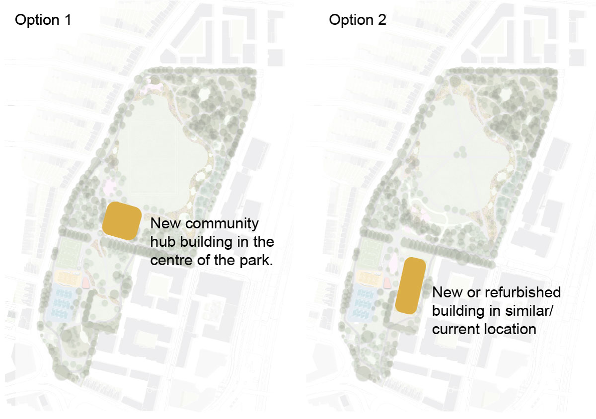
Option 1 and Option 2 community space site location diagram
Sports and Play
11. Location of sports facilities
Accessible and inclusive sports facilities with seating have been clustered along the western edge of the park in both Options 1 and 2, including relocating the tennis courts and creating a new multi-use games area (basketball, netball, volleyball) alongside the retained Artificial Grass Pitch. They proposal is for them to be located in the area currently occupied by the park depot and basketball courts.
By moving the tennis courts, this allows more greenspace to be created on the eastern edge of the park and creates a better sense of balance within the park and connection between the northern and southern sections of the park.
Image showing proposed location of sports facilities to western edge.
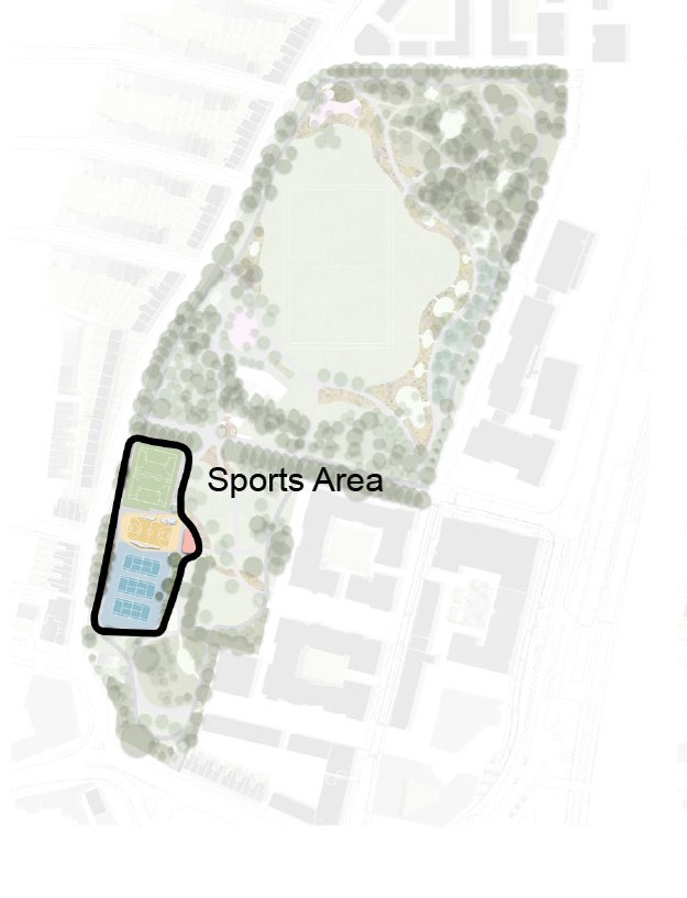
Location of sports area (this is common to both options but has been illustrated using Option 1)
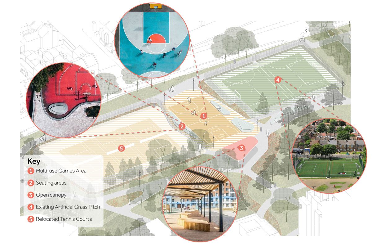
Suggested sports area arrangement
Sports & Play
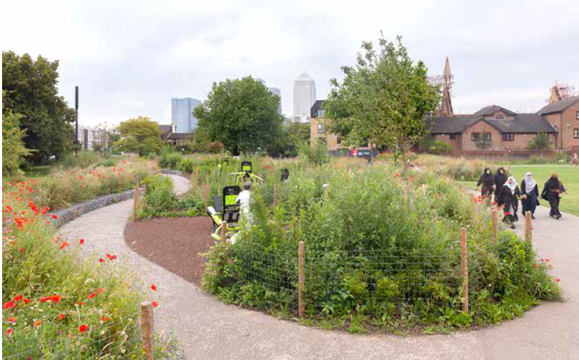
12-14. Activity/Fitness Trail
Through the improvement works the two-design options aim to encourage more people to use the outdoor gym equipment to promote active and healthy living.
Both options de-cluster or disperse the gym equipment and create a ‘fitness trail’ mixed with wildflower planting and modest privacy.
Additional, more flexible gym equipment could be located around the park in both options.
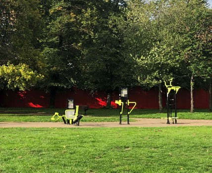
Top: Photo of existing outdoor gym equipment in Down Lane Park
Bottom: Fitness Trail, Bartlett Park by Levitt Bernstein Landscape Architects
BMX track
Both options propose to remove the BMX track in the southern section of the park, which is not well used.
This proposal would make better use of this part of the park, allowing a new entrance to be created from Hale Road and support a future connection across the park between Chesnut Road and Ashley Road.
 Photo of BMX track, Down Lane Park
Sports & Play
16-18. Play
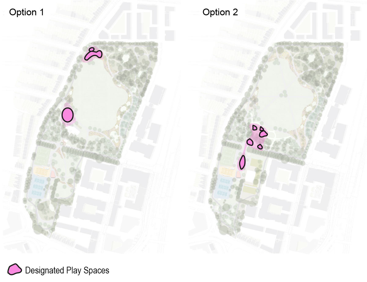
Both design options propose to improve children’s play facilities/spaces within the park, including dedicated ‘formal’ play spaces (swings, slides, climbing frames) as well as ‘informal’ play elements, e.g. ‘play on the way’ features like stepping logs and beams. The two design options relocate the play space further into the park, away from the busiest and most congested roads.
Option 1 proposes a dedicated ‘formal’ play space co-located with the proposed new (relocated) community hub building in the centre of the park. Other ‘informal’ play elements are dotted around the park with another ‘formal’ play area near the north-west Park View Road entrance.
Option 2 proposes a dedicated ‘formal’ play space co-located with the community building with further ‘informal’ play elements located close-by in the centre of the park.
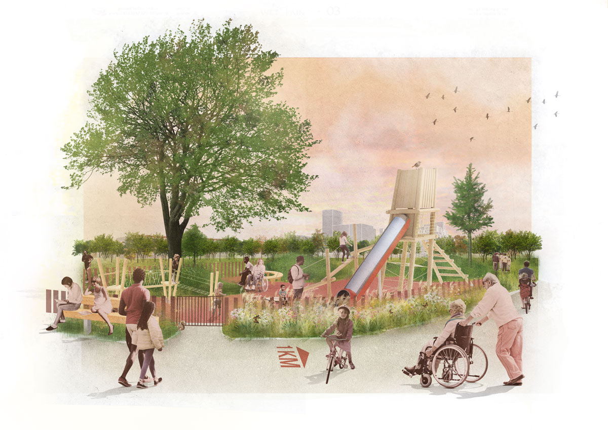
Concept image showing what formal play spaces could look like.
19-20. Ecology & Biodiversity
Both options 1 and option 2 propose to introduce extensive new planting throughout the park. Through co-design it has emerged that planting should engage people through touch (textures) and scent (smell). Whilst pleasant for all, touch and smell can be particularly appealing and stimulating for people with disabilities.

Sustainable Water Management
Along the park boundary with Ashley Road and Harris Academy, Design Options 1 and 2 propose planted areas where rain water and surface water can be collected in a sustainable way. This will help address local flooding and climate change.
Water can help planting thrive and creates new wildlife habitats. These shallow ditches or ‘swales’ may be largely dry, but wet in times of rainfall.
Woodland
Enabling residents and park users to get closer to nature is a key objective of the park improvements.
To the north east of the park existing trees offer a good opportunity for additional planting and habitat creation for wildlife. This might include ‘bug hotels’, log piles and wildflower meadow.
Signage and educational information boards can help raise awareness of the value of these types of spaces and how they help local wildlife.
Trees
Down Lane Park includes some high quality, mature trees, while others are in poor health, or diseased and (some) may have to be removed.
In some areas, trees have also been planted too densely to allow other stronger trees to thrive.
As part of our proposals some trees may need to be removed, but only where this is absolutely necessary. We will aim to preserve as many existing trees as possible while making sure that the conditions are right for them to survive and thrive.
We also plan to plant lots of new trees to significantly increase the overall number of trees in the park.
This engagement phase has finished
...